A ride through the enchanted forest of Fallbrook, De Luz & Rice Canyon
It was 6:30am when I got off NCTD bus 389 [Edit: Bus 389 was discontinued in 2018. Currently there is no bus servicing the area] at the new bus stop on Hwy 76 at Old Hwy 395 in Fallbrook. The bike that I had painstakingly cleaned and lubed only yesterday is now wet and dirty from spending the last 3 hours in thick fog at the front of the bus. It was still dark out, and I was quivering in the moist and cold morning air, cursing at myself for interrupting a good sleep at 3:30am in order to catch the early buses that would enable me to be standing so far away from warm shelter in such unpleasant weather at this hour of the morning. It is always like this the once or twice a week that I drag myself out of bed for a long and exotic country ride. But I don't own a car and this is what I have to do to fit in such a ride and still be able to get back home before dark.
The park&ride lot at the NE corner of Hwy 76 and Old Hwy 395.
There is a Mobil gas station with an attached K convenient store at the other end of the park-and-ride lot where the new bus stop is, but I was fully loaded with food supplies. I meant to first ride west on 76 to climb up Sage Road to Pala Mesa (it was my nemesis climb when I lived in Murrieta in the early 90's and used to ride my mountain bike down to Fallbrook once a week) before following curvy Wilt Road north. But it was cold and I didn't fancy riding on narrow winding residential roads when it's foggy out and the residents are pulling out of their driveways to go to work, so I decided to just go north up Old Hwy 395 instead.
Going north on Old Hwy 395 while indulging in some Schadenfreude looking at the heavy southbound traffic on I-15.
It is a boring stretch of straight road - made even less appealing by its constant gentle uphill grade (the type of phantom hill that pulls down on your bike without really giving you a real hill to climb) and its proximity to I-15. After a couple of miles I had enough of the non-existing view and turned left on Reche Rd to go through the more interesting (and slower traffic) part of Fallbrook, the rustic Live Oak Park.
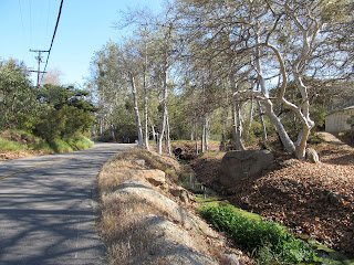
Live Oak Park Road in Fallbrook.
Turning right onto oak-covered Live Oak Park Rd is an escape into a fairy tale; rolling through the curvy fogged in lane that looked like it was hiding elusive elves and hobbits just behind the next corner. Trafficwise it would have been better to turn left/east on E Alvarado for some really gorgeous (and rather steeply undulating) riding, but I missed the turn due to absent-mindedness and continued on to Gum Tree Ln to Hwy 79/N Mission Rd instead. That cut off quite a bit of climbing in a bad trade for high-speed car traffic.
N Pico/ De Luz Rd turn off on N Mission Rd in Fallbrook.
It was a relief to turn right onto N Pico/De Luz Road for another lapse into fantasy land; this time one that would last more than an hour.
Did I mention that it was foggy out? Rolling deeper into the oak covered curvy De Luz Road in a fog was almost a ride into Tolkien's Tales from the Perilous Realm... or just the Old Forest from The Fellowship of the Ring. The encroaching oak canopies hiding haze-covered evil wights behind each bend, and I found myself looking around trying to catch sight of Old Tom Bombadil as Goldberry, Daughter of the River, hummed in my ears from the De Luz Creek nearby.
Harris Trail, branching up the hill to De Luz Heights from De Luz Rd.
After a cliff-hugging bit of climbing on De Luz Rd I took a detour right onto narrow but pretty well-paved Harris Trail for even more 'off-the-beaten-path' exploration. Alas, the fog was so heavy that all the gorgeous view from that exposed hill-scaling road was well shrouded in a uniform gray mist. An exasperating thing for a ride-for-the-view cyclist like me, so I parked myself on a dirt turn out and munched on the two apple turnovers that were weighing down my backpack and waited for a good 30 minutes for the haze to thin out a bit.
Life is like riding up winding Harris Trail in De Luz Heights; you never know what's lurking around the next corner!
It was a good move. Harris Trail is full of surprises. As I wind up the hill around a left-turning corner I first noticed a little stream of water running along the road's right edge, then I rounded the corner to find a little Asiatic oasis of lotus covered pond, not-so-wild daffodils and a grove of bamboo trees. It was so out-of-place in a most charming way imaginable!
More views from Harris Trail.
Just beyond it and the Shogo Mountain Rd turn off I pedaled through a thick patch of gray straight into avocado country. Then another bend of the trail's many little steep hills unfurled a line of tall palm trees beside the road. What the heck were tall palm trees doing on top of a rocky mountain range anyhow? By now the sun had started to flex its ray a bit and much of the fog had retreated to lower elevation (mind, the hills of De Luz Heights aren't that tall. Riding in this part of town you get a lot of short and steep up and down but no real long mountain climb).
De Luz Heights Rd. Looking down east toward Sandia Creek and looking up to its crest at Big Rock Ranch.
After a short descent to a T-junction I headed left/west up the really narrow De Luz Heights Rd. This is a charming country lane with hardly any flat bit to speak of. You are either punching up a steep little climb or you are nursing your brakes down another steep drop. It was nearing 9am (I had been taking my time photographing and bird-watching) and a few locals were out... along with their dogs. The dogs were mostly obedient, though they were also mostly unleashed, which meant a lot of cautious riding past them on the really narrow lane. The last bit of De Luz Heights Rd features a series of steep step climbs up to a hilltop stately occupied by Big Rock Ranch.
Looking back down De Luz Heights Rd from the top gave an interesting view of the road.
This bit of Joan Lane smelled particularly nice, thanks to the blooming bush of jasmine on the wooden fence.
Heading down the narrow, twisty and very steep descent of Joan Lane there was amazing view at every corner. De Luz Heights is a strange country; with lanes so narrow that two cars can barely pass each other, exotic trees popping out in the middle of nowhere on the ground of huge manor houses perched on hilltops like castles in the clouds.
Looking down on Daily Rd from Joan Lane.
Going down Cathy Ln to Ross Lake.
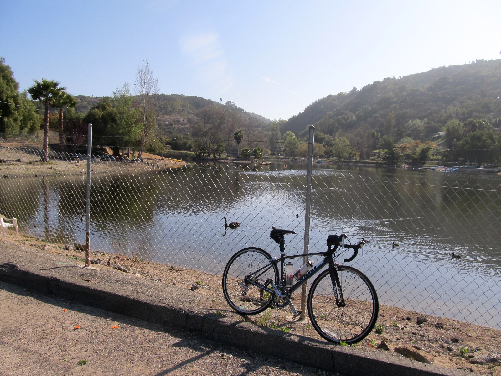
Ross Lake, all fenced in.
I was very happy to be riding down Cathy Lane toward Ross Lake rather than to climb up it's long-ish curvy stretch of 14% gradient. The lane became covered with tree canopies toward the bottom as I turned left onto Daily Road and made my way around Ross Lake, the little private loch in the middle of the mountain. The 10 acre lake is completely fenced in with locked gates on each side and is home to, surprise - surprise, the De Luz Yacht Club! Who would have thought there would be a yacht club hidden in a little manmade loch in the hills between Riverside and San Diego Counties, ay? Apparently the area was developed by Ross Daily in 1958 and the roads were planned from a helicopter. Maybe that explains the outrageous gradient on some of these narrow lanes?
A few friendly locals were out and about, fishing, jogging or walking the dog. Even Shiela, the lake's resident black swan, glided in to check me (or perhaps just my wacky looking road bike) out.
Shiela, the Ross Lake black swan, in the middle of one of her showboating spins.
A strange beast, that bird was. She floated to a halt a few feet in front of me on the lake and did a few slow spins in place. I took a few shots of her with the camera before panning around to focus in on something else. That caused her such indignation that she gave a terse loud squawk, turned right around and zoomed off to row with a family of American coots fishing nearby instead.
Daily Rd climbing north from Ross Lake.
I rounded the lake to the right and continued north on Daily Rd as it climbed up out of the little valley. This bit of De Luz is quite filled with interesting birds. I passed many varieties of sparrows, a few mourning doves, an industrious acorn woodpecker abusing a telephone pole just before Daily Rd plateaued off into Camaron Rd, and saw quite a few hawks patrolling the sky looking for a fresh brunch. I was able to shoot my camera off at a few while staying on the bike, and got off the bike in time to capture some others.
A redtailed hawk patrolling the road.
American kestrel, hooded oriole, American robin, yellow warbler, western scrub jay spotted along Daily Rd.
There were two misses that nagged at me a bit, though. The first was a white-headed bald eagle I spotted while rolling down a steep bit of the road and couldn't brake softly enough to not spook him off before I could fish my camera out. The other was a huge fat roadrunner that crossed the road not more than 30 yards ahead of me. Alas, I was no wiley coyote sauntering up the steep climb, and needed both of my hands on the handle bar.
Hilltop view from Camaron Rd
More treed in riding on De Luz - Murrieta Rd
Daily Rd turned into Camaron Rd as it crested the top of a rather photogenic hill. I was back in avocado country again as the road descended down to intersect with De Luz - Murrieta Rd. This was the same road I started out on in Fallbrook, of course, but my detour had taken me up the hills rather than staying in the valley with De Luz Creek. I rejoined De Luz Rd northeast and was soon enjoying more enchantingly curvy oaken forest riding. A family of rock swallows buzzed overhead as I passed their home bend on the road.
A creek crossing on De Luz Rd
The Margarita Creek running along the east side of De Luz Rd
You know you're nearing the turn off to Temecula when De Luz Rd goes from rustic to manicured.
There are many creek crossings on De Luz Rd. These are concrete crossing with diagonal ruts etched onto the pavement that feel pretty much like riding over a cattle crossing. They are best traversed at speed with flexed arms and knees and light grips. Take time to check out the little creek if you ever ride this way. It even has a little waterfall at one of the bend!
Cross Creek Golf Course off from De Luz Rd.
Rancho California Rd, a bit of climbing before a fun 8% grade descent into Temecula.
Rancho California Rd crest.
When the roadside vegetation went from rustic to manicured I knew it was only a few miles before I get to the Rancho California Rd turn off for Temecula. Rancho California Rd was a boring stretch of this ride, I'm afraid. Turning east, it goes straight up a long-ish climb with nary a view to speak of. I was tempted to turn south off it to return to Fallbrook via Sandia Creek Rd, but a run into Temecula held the promise of lunching at my favorite restaurant when I used to live in town, Peony's. I had been dreaming of their house special chicken ever since I took off for this ride... And so up the boring Rancho California Rd I rode until it peaked high above what is now a real city (amazing how this place had grown in the last decade!) when I could finally shift to the big ring again and coast down the curvy 8% grade east face of the mountain.
Rancho California Rd at Ynez Rd in Temecula
Alas, Peony's was not where it once was in the shopping complex between Rancho California and Margarita Rds. I can't tell you how demoralizing that was! (I only found out later that they had moved a few hundred yards west on the same road... and I rode right by it twice without noticing it!)
Rainbow Canyon Rd carving its way south along the rocky mountains.
Snow-capped San Jacinto Mtn was visible from Rainbow Canyon Rd
Frustrated, I snacked on another granola bar and headed south on Ynez Rd, through the ranchos along La Paz Rd to Hwy 79, where I had to share a hundred or so yards with a lot of cars before I could turn south on Pechanga Pkwy and then right on Rainbow Canyon Rd on my way out of Dodge. I should say, it is quite less fun going south uphill on Rainbow Canyon Rd than the other way around. The road is quite curvy with lots of broken glass debris on the shoulder.
One of the many flowers & cactus farms in Rainbow. Mt Olympus in background.
Rice Canyon Rd at 8th St in Rainbow.
There was not much to see in Rainbow proper as I rolled through and took the quick turns onto 8th St and then Rice Canyon Road. I was tempted to veer left onto Rainbow Heights Rd for a scenic detour, but it was getting quite warm and more climbing didn't feel very inviting just then.
Rice Canyon Rd and its ruts-hiding tree shadows.
Oh, what a fun ride going south on Rice Canyon Road could be if only the pavement wasn't full of wicked long ruts that blended themselves in perfectly to the all too abundant tree shadows? Going south from Rainbow on Rice Canyon Rd is mostly downhill, though there are a few abrupt rollers to climb up in the middle of it. The road is very narrow and tree shadows makes it hard to spot the many ruts and potholes and all the other tire-eating thing rural roads like to hide up the middle of their pavement. In the southern bit of Rice Canyon the view opened up over avocado farms, though, and the road ended t-boned to the north side of a curve on Hwy 76.
Highway 76 west from Rice Canyon Rd toward I-15.
The two or so miles west on Hwy 76 between Rice Canyon Rd and my bus stop on the far side of the freeway were the tensest two miles of the trip even though I was traversing it just past noon on a weekday. Thanks to Pala and Pauma Casinos just up the road, this narrow two laned (and mostly shoulderless) highway always carries more big car traffic than is comfortable to share my tiny little bicycle with. Luckily, once I got to Rosemary's rock quarry another lane and a wide shoulder was added to the westbound side. The shoulder was mostly useless because of all the rocks scattered on it, but the extra lane sure helped.
All in all it was a good 56 miles ride, most of it very scenic and interesting. I hope to go up for more variations of the route before the weather gets to be too hot for such a ride (I reckon I still have a month or two left before De Luz gets too warm for me). I should note for anyone looking to try out this route that there is no water stop to speak of on the De Luz - Harris Trail - Camaron variation from Fallbrook to Temecula (if you stay on De Luz Rd all the way, though, there is water at the fire station), and the same goes for Rainbow Canyon & Rice Canyon Rd, so water up before you leave Fallbrook and Temecula and you should do okay.
Hi Niven, They were pretty steep indeed, though luckily for me they were also mostly short. I can one hand up 14% grade as long as it isn't longer than 50 yds or so. :o)
Hey Ashley! They way you're progressing I bet you'll be up to it by winter indeed. :o) It's pretty gnarly on the legs even though it's just 56 miles, but the view cures all aches and pains... pretty much. ;o)
Just discovered your blog. You have a way with words. I've ridden those hills and your writing style beckons me to revisit. The last few times I've climbed those hills were at a pace not to get left behind lest I get lost in that maze of back roads. Didn't really have the chance to stop and smell the roses.
Hey Jerry. Thanks very much! :oD De Luz Heights is always worth a revisit... preferably at leisurely pace and with lots of time to explore! :o) I still have to go back up there soon. Gotta check out Shogo Mtn Rd (off Harris Trail) and the little road up the flank of Monserate Mtn west of Rice Canyon Rd. Too bad it's such a distance away or I'd ride those areas all the time! :D


Can't believe you were riding one-handed filming while going up some of those roads. They look pretty steep!
ReplyDeleteNiven
Hi Niven,
ReplyDeleteThey were pretty steep indeed, though luckily for me they were also mostly short. I can one hand up 14% grade as long as it isn't longer than 50 yds or so. :o)
I want to take this trip!!!
ReplyDeleteHey Ashley! They way you're progressing I bet you'll be up to it by winter indeed. :o) It's pretty gnarly on the legs even though it's just 56 miles, but the view cures all aches and pains... pretty much. ;o)
ReplyDeleteJust discovered your blog. You have a way with words. I've ridden those hills and your writing style beckons me to revisit. The last few times I've climbed those hills were at a pace not to get left behind lest I get lost in that maze of back roads. Didn't really have the chance to stop and smell the roses.
ReplyDeleteJerry G (palomar ride)
Hey Jerry. Thanks very much! :oD De Luz Heights is always worth a revisit... preferably at leisurely pace and with lots of time to explore! :o) I still have to go back up there soon. Gotta check out Shogo Mtn Rd (off Harris Trail) and the little road up the flank of Monserate Mtn west of Rice Canyon Rd. Too bad it's such a distance away or I'd ride those areas all the time! :D
ReplyDeleteThere is now or at least last summer a little rest stop on De Luz; a welcome surprise to the weary climber. Stocked with drinks and baked goods too.
ReplyDeleteJerry