Wednesday, October 31, 2012

Halloween bike ride thru Bay Park & Clairemont

It's (supposedly) the spookiest night of the year. I'm afraid I forgot to shop for candies to ward off all the sweet-toothed local goblins and monsters. Luckily I live in a unit that isn't very visible from the road, so no trick-or-treaters have wandered my way so far.
The Cardiff Kook as the Halloween Zombie...
I did venture out for a bit earlier today, though. Gotta give the computer a little break from spending too much time with me or it'd go ape. Today was a late-October-ish day with a lot of sun and comfortably cool temperature. I meant to only go for an hour long easy ride, but after a few sprints up the rolling hills of Mission Hills I got enthusiastic and decided to do a little route-scouting ride in hilly Bay Park.
Tantalizing Illion St climb from Tecolote Canyon Nature Park
No Bay Park ride would be complete without a trip up fearsome Illion St, of course. I had a good look at that terrible hill from a new vantage point today when I was investigating Tecolote Canyon Nature Park nearby. I have a feeling that this hill will never be a comfortable climb for me, but my lungs weren't exploding by the time I crested it today... considering that I was in blue jeans rather than comfy cycling kit, that was something quite worth being pleased about.

I headed east on Milton St, away from Mission Bay. There's a bit more climbing to do there, but it paid to look behind me every now and then. Milton St's ickiest section (15% grade according to the road sign) is between Galveston and Illion, but I didn't have to ride it since I came up Illion... not that that was less of an exercise. After a bit of a faux flat it kicks up into about a block worth of 12% grade before leveling out toward Bergener Blvd. I hung a left there and went all the way up to Mt Acadia Blvd with it, but if I ever take anybody riding up here I'd probably detour east a couple of blocks to Cowley Way (a bit more climbing, but worth it to miss the heavy school traffic).

Mt Acadia Blvd just before its 10% grade drop into Tecolote Canyon (from the west).
A right turn at Mt Acadia and a hair-raising plunge down into Tecolote Canyon. I used to drive through here when I was still golfing and remembered there used to be a stop sign at the bottom where it intersects with Snead Dr (to go to Tecolote Golf Course). Now the stop sign is only on Snead and not Mt Acadia (which has also gotten much wider!), so this stretch is much more fun for cyclists since you can sling shot part of the way up the other side.


Again, next time I ride thru here I'd hang a right at Acworth and then left on Boyd instead of staying on Mt Acadia after getting back up from the canyon. Another school and its traffic. By the time I got to Genessee I had already been out for more than an hour, though, and needed to get back (despite of appearance, Smorg does work many hours a week) so I turned south and followed Genessee down to Linda Vista Blvd. A bit past Ulric St turn off I spotted a rather tantalizing sign off on the right side of the road. Filipino lumpias! If you haven't tried one of these, my friends, you've got to. They are all that's right about deep fried food!

U of San Diego's Alcala campus off Linda Vista Blvd
Anyhow, a big attraction about going south on always busy Linda Vista Blvd is passing by the gorgeous campus of the University of San Diego, of course. Lots of cars on the road, but the bike lane is wide and mostly well paved. There are a few icky spots once you hit the really downhill bits after USD, though. One was a round manhole that was indented quite a bit below pavement level and covers the entire bike lane (you definitely have to swerve into car lane to avoid it, so spot it early to allow time for a safe merge).

This is what you look like when you lose yourhead over Halloween, I guess.
Took Morena Blvd down to Old Town, then climbed up Juan St back into Mission Hills. That was hungry work, though not so hungry as to not pedal slowly thru the area looking at some rather cool Halloween decorations.


Some folks really go all out with this spookifying of their property thing... It was great! I almost liked Halloween decor better than I do Christmas. More variety and more humor. I'm afraid I didn't put anything up at my pad, though. It's out of the way and nobody would see it anyway. Besides, the place is guarded nearly 24/7 by a black cat... That ought to be spooky enough to begin with, oughtn't it?

The lumpias made it home intact, of course. I tossed 'em into the oven while I took a shower, and when I came back out they were perfectly hot and crisp.
Yummy Filipino lumpias from Olga's in Linda Vista.
I guess I didn't lose any weight after all that riding after all!

Sunday, October 21, 2012

Photos from Giro di San Diego Gran Fondo 2012

Some photos from this year's brutal Giro di San Diego gran fondo. If you rode or volunteered in it and see yourself in any shot, feel free to download the shot(s) for your own use.
Giro di San Diego registration tent at Bike Expo in Solana Beach.
There was a Bike Expo and Taste of Solana Beach festivities the day before the big ride.
Race packet contents

All the riders got their race numbers (one to attach to the bike's handle bar and the other to the back of the jersey), race bible (containing info and route maps), and a few swags from the event's sponsors. 
Race bible has maps of all the fondo rides.
They must have had the race bible printed really late since the routes were changed significantly 5 days before race date, and the book contains the updated routes. I signed up to ride 106 miles and ended up doing 111.

I arrived an hour before start time to find stuff still being set up.

Registration area the morning of the ride. Volunteers wore neon green t-shirts.
This fondo wasn't quite a well-oiled machine. Still, all the volunteers and organizers worked really hard to get things rolling.
Revolution Bike Shop mechanics checking bikes out before start time.
Thanks a bunch to Revolution Bike Shop of Solana Beach for providing mechanical support at the start/finish and also along the routes! 

First group of gran fondo riders at the start line.
I'm afraid I didn't take many shots once I took off. I figured the organizer would have photographers taking professional shots along the route... At any rate, the group I started out with went out really hard from the start and ran practically all the traffic lights along Lomas Santa Fe Rd as they headed to the PCH. I had to run the first red light along with them since I was right in the middle of the peloton and didn't feel like causing a nasty bunch crash by hitting the brake. I dropped out of the group right after the intersection, though... and did the same (without running lights) with the other 2 or 3 groups that followed. Somehow I doubt that any of those speedsters were professionals... From what I know, the pros generally take off leisurely and pick up speed toward the end while amateurs do the exact opposite. To be clear, the race bible specifically instructs Giro di San Diego riders to obey all traffic laws (including traffic lights and stop signs) at all time.
Elfin Forest Rd was still under construction, so all the fondo routes were re-routed up San Elijo Rd toward San Marcos.

The gran fondo and the medio fondo riders went all the way thru to Escondido. Our first aid station was on Valley Center Rd just south of Lake Wohlford Rd. The volunteers here didn't get their neon green shirt, but still managed to feed us hungry cyclists delicious peanut butter and jelly sandwiches, watermelon, chips and sport drinks.

Up Valley Center Rd toward the mountains

Man, was I glad we climbed Cole Grade Rd from the south side...
The medio fondo riders veered off to climb Lake Wohlford and then turn back. We gran fondo riders went up Valley Center Rd to climb fearsome Cole Grade Rd, happily from the south side (the original route would have us climb that thing from the north side right after Mt Palomar... Eeeek!).

By the time I hit the base of Palomar South Grade Rd the sun was feeling macho and seemed bent on scorching the joy out of all living things. There was a company of paramedic at the turn off with warm coolers of water and a bunch of O2 tanks. Their thermometer read 103F and quite a few exhausted riders lined up to be revived by some fresh gas.
Riders taking a breather in a shaded spot along S6 up Palomar Mtn. SAG cars along the route provided energy bars and water.
Never saw any cow on the mountain, but there are 4 cow crossings along South Grade Rd that were icky to ride over.

Yes, I got passed by a few really fit ladies... I plead guilty to being slow!
Even seasoned century riders were taking frequent breaks at various little shaded spots along the way up that last 6 mile bit of continuous 6.5% grade climb. 


Half way up I passed one exhausted rider walking his bike up. The dude was spent, but still wasn't willing to give up! Another dude ran out of water and food a mile or so from the top. Luckily I started with 3 bottles and still had one nearly full one left then, so I half the liquid with him and gave him my last energy gel before going on up the road. He came riding up a bit after. Gotta give these riders kudos. They were down, but they refused to throw in the towel!


There was a volunteer guy at the base of the climb (on Hwy76 just past Valley Center Rd) recording our bib number and time for the King of the Mountain contest. There wasn't anyone recording our finish time on the top of the road by the time I got there, though. At any rate, plenty other volunteers were there in front of Mother's Kitchen with tablefuls of goodies; apple pie wedges, watermelon slices, chips (good source of replacement salt!), and more peanut butter and jelly sandwiches along with bottles of Pepsi and sport drinks. 

You'll pardon me for not taking any photo on my way down twisty South Grade Rd... I maybe moderately crazy but I'm not suicidal. Thank you very much. I did turn back and took a shot at a group coming down Lake Wohlford Rd after me while waiting for the traffic light to turn green. That was my last road shot of the day, though. It was almost 3PM then and I was overheated beyond caring. To heck with fishing out the camera to shoot anything. I just wanted to make it back to Solana Beach before dark!
The salad was soggy and the pasta cold, but the lemonade and the iced tea were cold and tasted wonderful!
Which I did... just in time, too. They stopped serving food 10 minutes or so after I arrived.

Thanks very much again to all the volunteers at the gran fondo!

Links:
- Giro di San Diego gran fondo official website
- My pre-ride of the mountain part of the gran fondo route

Pre-riding the hilly bit of the 2012 Giro di San Diego gran fondo (Lake Wohlford, Palomar South Grade, Cole Grade Rd) II

Part 1.


That's the same road I'm on now, South Grade Rd (S6). The wiggly thing kept doubling back on itself!
So there I was, leaning against the Palomar Artesian Springs rock basin in the shade on the hillside of South Grade Rd considering my options: I had never ridden this way before and didn't know how far I still had to the top. It was now past one in the mid-summer afternoon and I only had 2 gulps of water left in my bottles. I knew that if I turn around before the top, I would be coasting downhill all the way to the Oak Knoll Campground (and its little shop with cold drinks and even ice-cream)... so perhaps it wouldn't be that foolish to keep going up until I really ran out of all water - something I wouldn't do in other circumstances. I should have paid more attention to the roadside mile posts at the start of the climb, but the road was supposed to be only 6 miles long and I had passed 47.2 (and remembered 41.something on my way up), so I had to be quite close!
OMG! This road wasn't endless after all!
Sometimes you just have to risk it a little bit (especially when it is well calculated). This time it paid to resolve to go on since the bend that houses the artesian springs turned out to be the next to last bend from the top of the South Grade Rd climb. The S6 junction with S7 (East Grade Rd) marked the official top of the road, and the mere sight of the sign from 150 or so yards away was enough to adrenaline-rushed me up the last bit of the slope.
Smokey the bear is always looking to beat wildfires up with his shovel.
Cresting the top to pay a visit to Smokey bear and his fire danger level sign I gained a new appreciation for the eternal plight of the boulder-hauling Sisyphus. Not only did I get to reach and stay at the top (well, not the real top of the mountain per se, but the top of the official South Grade Rd climb), I would also get to rest up and refuel at the famed Mother's Kitchen Restaurant, too!
I think the place is famous for chilli, but it was 88F outside so I went with cheese quesadilla and fountain soda instead.
The dining room was very nice and clean in a charming mountain rustic sort of way. There was even an outdoor patio dining area out the back of the place. The hostess was really nice. My lunch costs $10 (including tips). Not bad at all. I loved that they have fountain drinks, so I could put fill my bottles with ice and Sprite, and they would stay cold for a while into my descent.
Palomar Mtn General Store, Mother's Kitchen Restaurant, Post Office
Next door were the Palomar Mtn General Store and the post office (and also the public restrooms in a separate building. Very nice and clean). I dropped in at the post office to send off a postcard, then wandered into the general store in search of energy bars and an extra bottle of Gatorade for the road
Not feeling very local just now...
..and sure wasn't expecting to find a bunch of Russian Orthodox icons, matryoshka dolls and even Buddha icons and statuettes on the retail shelves! They do have candy & energy bars for sale along with coolers of cold drinks, though (no fountain drink, unfortunately). 


It had been a while since I got to ride down a winding 7% grade highway that was longer than a couple of miles, so I was more interested in memorizing this technical descent than I was at living out one of my all time favorite youtube sport clips in real life. This was more so when I had a near miss and only avoided hitting a pothole that was laying in ambush just behind a right-turning switchback by less than 2 inches. After which I sat up and ate the wind the rest of the way back to Hwy 76... which was pleasant enough above 3500 or so feet. Below that the air turned so hot that it felt much like having my face stuck in front of a blow-dryer for 5 miles in a row. 
A cow crossing on South Grade Rd.
I might let it rip coming down this hill during the Giro di San Diego, but it was a good thing that I didn't my first time around. The descend is very technical, and there are the 4 cow crossings that took some getting used to (I never saw any cow on that mountain, but it was unsettling screeching down the road on two skinny wheels doing 35 mph to see the pavement ahead interrupted by iron cross bars... It's best to get out of the drop onto the hood and keep the grips light as you flow over the thing... Do not apply the break! It's less jarring going over them at speed).
Cow pasture on the faux flat section of Hwy76 west of South Grade Rd
Alas, my camera batteries died shortly after I got back down on Hwy 76, so no more photo from the ride. It was just as well... I had heard about Cole Grade Rd before, but nothing prepared me for the sight of the base of that monster a mile or so wsw of Hwy 76 turn out. The climb was only 3 miles long (whereas Palomar Mtn climb was 12; 6 miles on 76 and 6 miles on South Grade Rd), but at 9% grade in 90+ F on a midsummer day, after completing an HC category climb... this was something quite inhumane! There was no rest stop/water hole along the route either... I must have stopped 4 or 5 times before the top, my legs felt like bombed out noodles and my brain cooking inside out.

There was no fun descent to be had after the apex of the climb either. The road was considerably less steep on the south side, and there were two or three rollers to go over before the legs had had enough time to recover. By the time I reached Valley Pkwy on my way back to Del Lago bus station I was quite convinced that I wouldn't be able to complete the Giro di San Diego gran fondo route. It wasn't Palomar that was going to kill me, but Cole Grade Rd! skull 

I was only doing a portion of the ride (68 miles rather than 106) and I could hardly get back up the Bear Ridges, the mild hump on Bear Valley Rd coming back south. On the real ride next week I'll be starting at near sea level in Solana Beach and would have plenty of icky rollers (San Elijo Hills included) on my way back west after mile 70.

But, hey dudes, I'm not a professional cyclist and I'm not entering a race. I only signed up for the gran fondo because I wanted to climb Palomar South Grade Rd in a group... (a bit ironic there. I wanted to ride up that thing in an organized group for safety reason, but here I was, going up it solo the weekend before because I don't like to ride any route blind! Bwahaha). So now I know I can climb Palomar from the steepest side along with Wohlford and Cole Grade. Hopefully this takes a lot of the sting off when I do get swept up by the broom bus next weekend...sick 

Update: I did survive the Giro di San Diego gran fondo... though not a little fast pace group ride the weekend after (crashed out and will be off the bike for a while).

Thursday, October 4, 2012

Pre-riding the hilly bit of the 2012 Giro di San Diego gran fondo (Lake Wohlford, Palomar South Grade, Cole Grade Rd)

On Friday September 7th I got up at 4:30am to catch the 5:55AM bus up to Escondido to pre-ride the hardest section of the Giro di San Diego gran fondo route a week later (had to stop to see to a neighbor's dogs before leaving, hence the early wake up time). Long bus rides to remote cycling routes is the price one has to pay for not having a car, I'm afraid. I'm lucky that there's a bus connecting San Diego to Escondido, though. I wouldn't be able to get up there for less than $10 otherwise!

I had planned on taking off from Del Lago bus station in south Escondido by 7:10AM, though I drew such a 'safe' bus driver that she refused to go faster than 50 mph on the freeway even though the speed limit was 65 or 75 (I don't know... it seems to me that driving too slow on a freeway is just as unsafe as driving too fast!). As a result, I didn't get to Del Lago station until 7:45AM. Thirty five minute delay didn't seem like much when I started out... until a few hours later when the sun started its attempt to melt me into a mushy goo climbing up the big mountain in the heat of noon. Anyhow, here's the route: https://ridewithgps.com/routes/33583639 (69 miles, 7799 ft elevation gain)


It was cool enough at 7:45AM to keep my arms and legs warmers on as I rode up Del Lago Blvd to Beethoven St and took the bike path on the north side of the road down to Bear Valley Pkwy.

Bike path between Kit Carson Park & Beethoven St in Escondido.
On the left side was Kit Carson Park. Looked much like an ideal start/finish place for rides up in this part of San Diego. There were a few joggers and dog-walkers using the path. Pavement was pretty good, though lots of brush debris that may hide tire-puncturing goat heads.

Bike path along east side of Bear Valley Pkwy
Turning north on Bear Valley Parkway past the San Pasqual turn off (you'd turn right there to go to the Zoo Safari Park) another bike path appeared on the right (east) side of the road. An extremely ill-maintained one this time, though I had to use it since the main road has no shoulder and the cars were in the hurry to get to work. There was a bit of gentle climbing to warm up a bit before really turning uphill on Lake Wohlford Rd.
Bear Valley/Valley Pkwy at Lake Wohlford Rd
The real hills began going ENE on Lake Wohlford Rd, with the narrow road shoulder that was well populated by pebbles of various sizes that had slid down from the cliffs above. Aside from a couple of semi-trucks that whipped by me in a shower of dust and the dreaded bike-sucking slipstream (I'm never keen on being vacuum-pulled up a hill behind a truck when there are other trucks coming up behind me!), it was a nice 2 miles long ascent on a moderately scenic and pleasantly curvy road. The gradient was pretty consistent at 5-6% until the bridge near the top of the climb.

Lake Wohlford Rd
Lake Wohlford
Lake Wohlford turned up on the right (east) side of the road, looking all cool and majestic, and well visited by hawks and water birds. Alas, the place is now only open on weekends. Beyond the lake were a few restaurants and shops. I didn't stop since I still had plenty of water and the sun was getting hotter all the time.
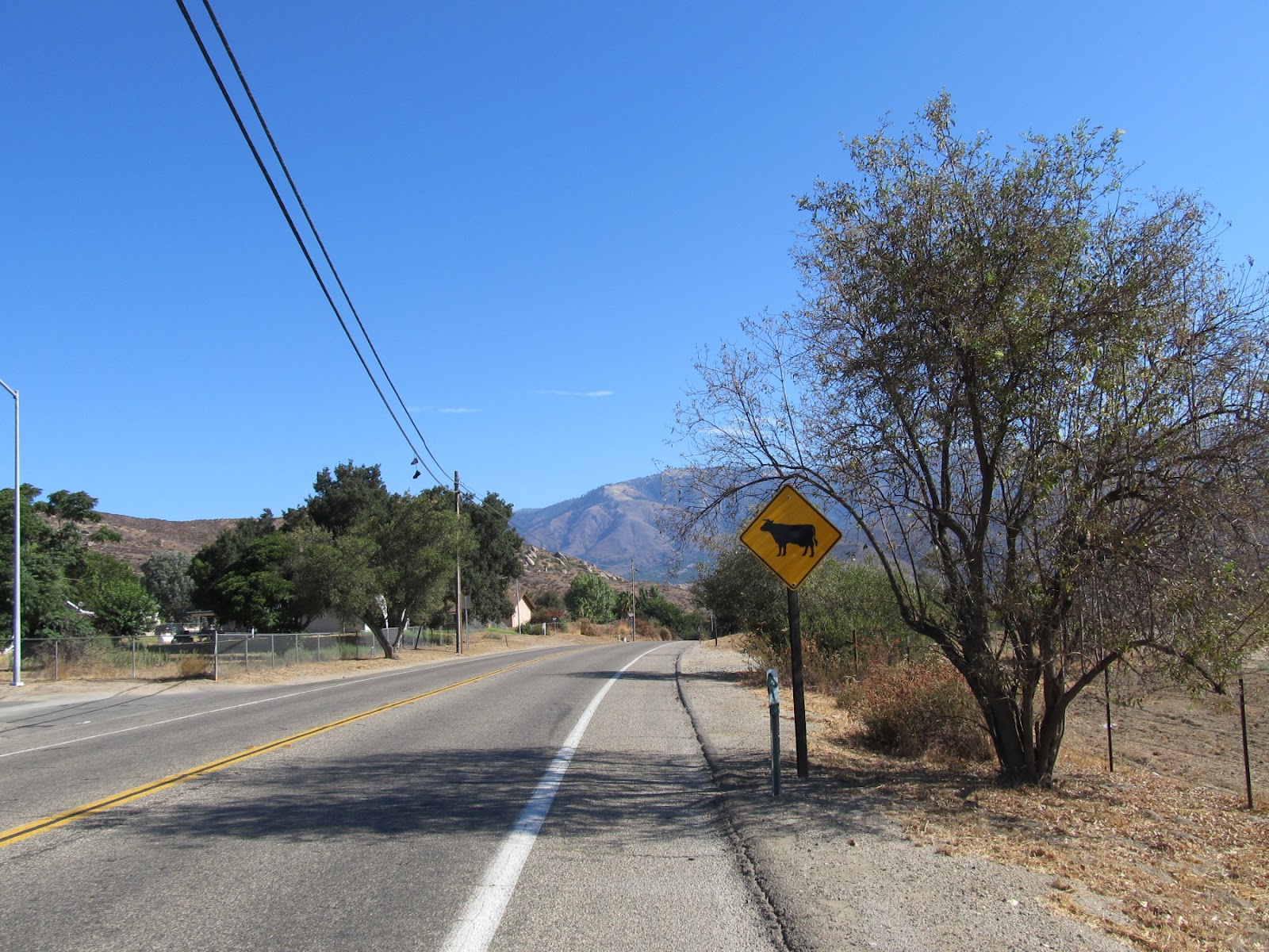
Watch out for those cow crossings. They're grated irons across the pavement... almost as bad as railroad tracks.
After the lake, I descended into Valley Center and its dairy farm scent. The sun was getting high in the sky and the temperature was on the way up. Turning right onto Valley Center Rd toward Rincon I rolled down the most scary bit of riding for the entire day when the narrow and ill-paved road hugs the hill to the left and drops right down to the valley floor.

Cars and trucks trying to speed past on my left, a huge vertical drop to my right, and the road surface under my tires that looked and felt like it had caught a particularly virulent strand of small pox. The bike bounced around so much that it was all I could do to hang on for dear life. By the time Valley Center Rd finally leveled out my arms and legs felt like they had caught the spell Gilderoy Lockhart used in his attempt to mend Harry’s broken arm in ‘Harry Potter And The Chamber of Secrets,’ – quivery and quite practically boneless.
View of the mountains to the east of Valley Center Rd (S6)
Naturally I didn’t manage to get a photo of that stretch of the road… As it was, my favorite water bottle bounced its way off to Lalaland some way down the grade without me even noticing. I only found out about it when I reached down for a drink to find a whole lot of nothing being held by the down tube bottle holder. Annoyed, I was, though I wasn’t all that concerned since up ahead was the big building that was Harrah’s Casino at Rincon, a gas station and a 7/11 store where I popped in and downed a 6 chocolate donut package and a bottle of Gatorade before re-emerging with a fresh bottle of Sprite to serve as my second ‘water’ bottle (along with using the restroom and re-filling the other water bottle with tap water, of course).

Water stops at Rincon
I wasn’t familiar with the area, so I decided to fill up at the first opportunity I saw… The 7/11 store was well stocked and has a really nice and clean restroom, though food price was a bit steep. Next time I ride in the area I would try the Rincon Market down the road instead. Don’t know if it is better, but at least I’d be supporting local business.
Jilberto's Taco Shop on Hwy 76 just east of Valley Ctr Rd, the traditional start of Mt Paloma climb.
Turning right onto Hwy 76 I spotted Jilberto’s Taco Shop on the left side of the road that usually marks the start of Mt Palomar climb for local cyclists (from this point on the road goes up at 6% grade and doesn’t level out any until a little stretch just before the turn off to South Grade Rd).

It’s 17 miles to the top of the mountain from here. It was also 11AM and the sun was flexing its muscles a bit and I was starting to appreciate every little bit of shades the road side trees threw my way. A mile or so up the road was the turn off to Cupid’s Castle; the daft resort castle that you could actually spot from the road if you looked for it, which I did if only to mark it as the ‘a mile or so back to the Valley Center Rd junction’ landmark for the way down.
Hwy 76 climbs on and on east toward Mt Palomar.
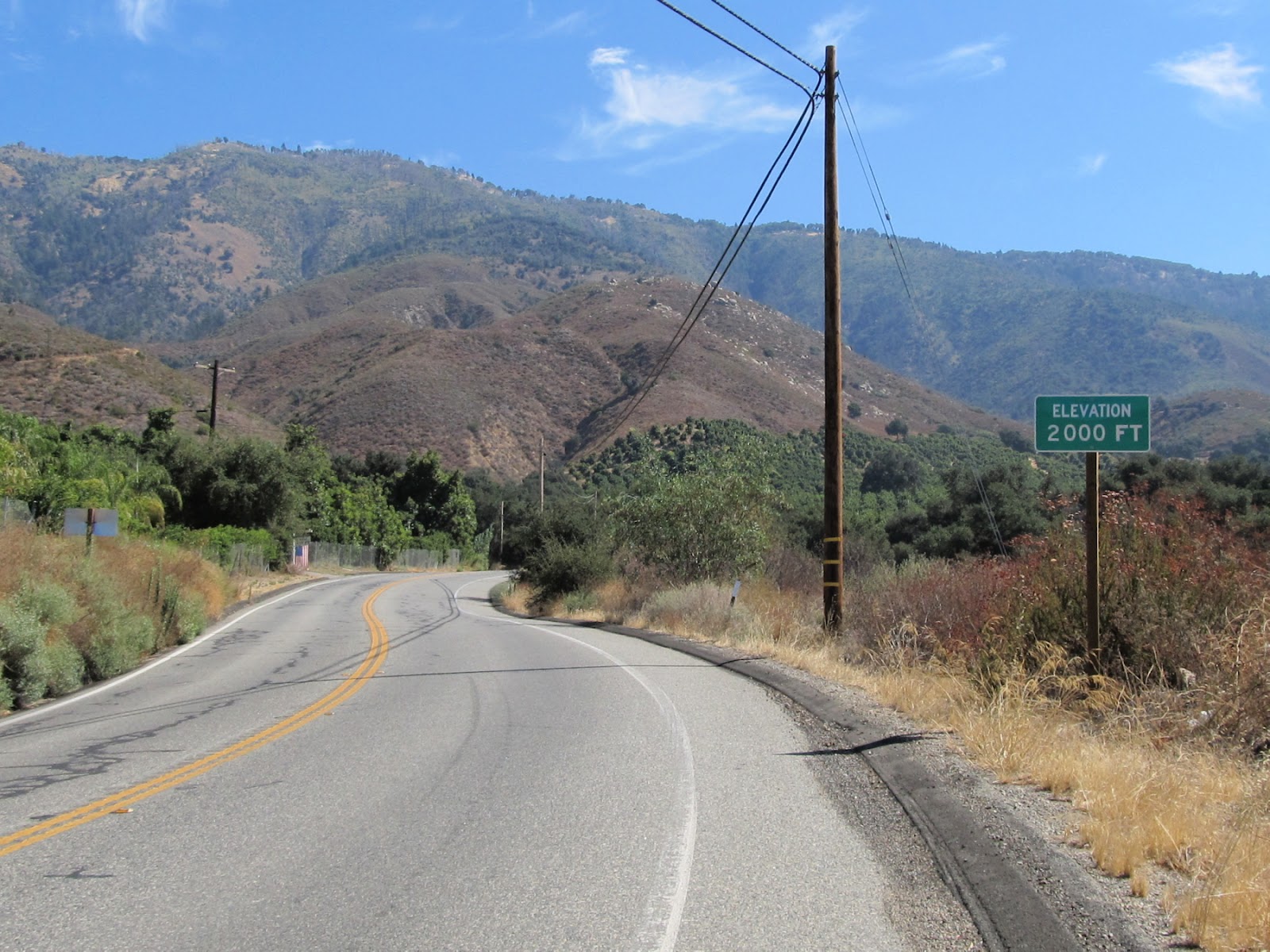
Turns on the road didn’t bring any relief in its gradient. After what seemed like miles a green sign finally appeared on the side of the road marking 2000 ft elevation. At what elevation did I start riding from this morning? I had no idea! I knew that the top of Palomar Mtn was a bit over 5000 ft, though. That meant I had 3000 vertical feet yet to climb. An icky thought when my legs were already starting to feel a bit worn.

Spinning the next-to-easiest gear on up the road as my supposedly sweat-proof sunscreen started to melt into my eyes. The road seemed to be endless! It was supposed to be only 10 or so miles to the junction… but 10 miles on a 6% incline slope tend to dilate time a bit. But just as I started to seriously wondered if I had missed the turn off to South Grade Rd somewhere in my myopic ‘climbing a bit of the road at a time’ mode, the road leveled out (and even dropped a little bit, just enough for a little recovery coasting) and the turn sign turned up on the side of the road.

To be honest, as happy as I was to finally turn onto the S6 (South Grade Rd) up the mountain, I was even happier to see that the Oak Knoll Campground at the base of the road had a store that sold cold drinks! I was hoping for fountain drink (so I could put ice in the bottles), but they only had bottled drinks… But they were cold, and there was even a chest of ice cream bars, too (now you know why it took me so long to complete the loop. I kept stopping to eat!)!
Oak Knoll Campground general store.
Loaded with 2 ½ bottles of drinks (1 ½ bottles of Gatorade and 1 bottle of water) – I would have taken 3 full bottles, but my light backpack was already feeling like the big globe on Atlas’ shoulders – I turned back up South Grade Rd and immediately started suffering. It didn’t help that every few minutes I would hear a motor roar from above and one or a pair of motorcyclists in full body armor would come flying out of the blind curve up ahead.
Here comes another pair of speedy motorbikes roaring down South Grade Rd.
You know how some people can’t stand the sound of paper squeak or metal on metal rubbing? I can’t stand the sound of revving motorcycle engine… especially the unmuffled Japanese-made ones.


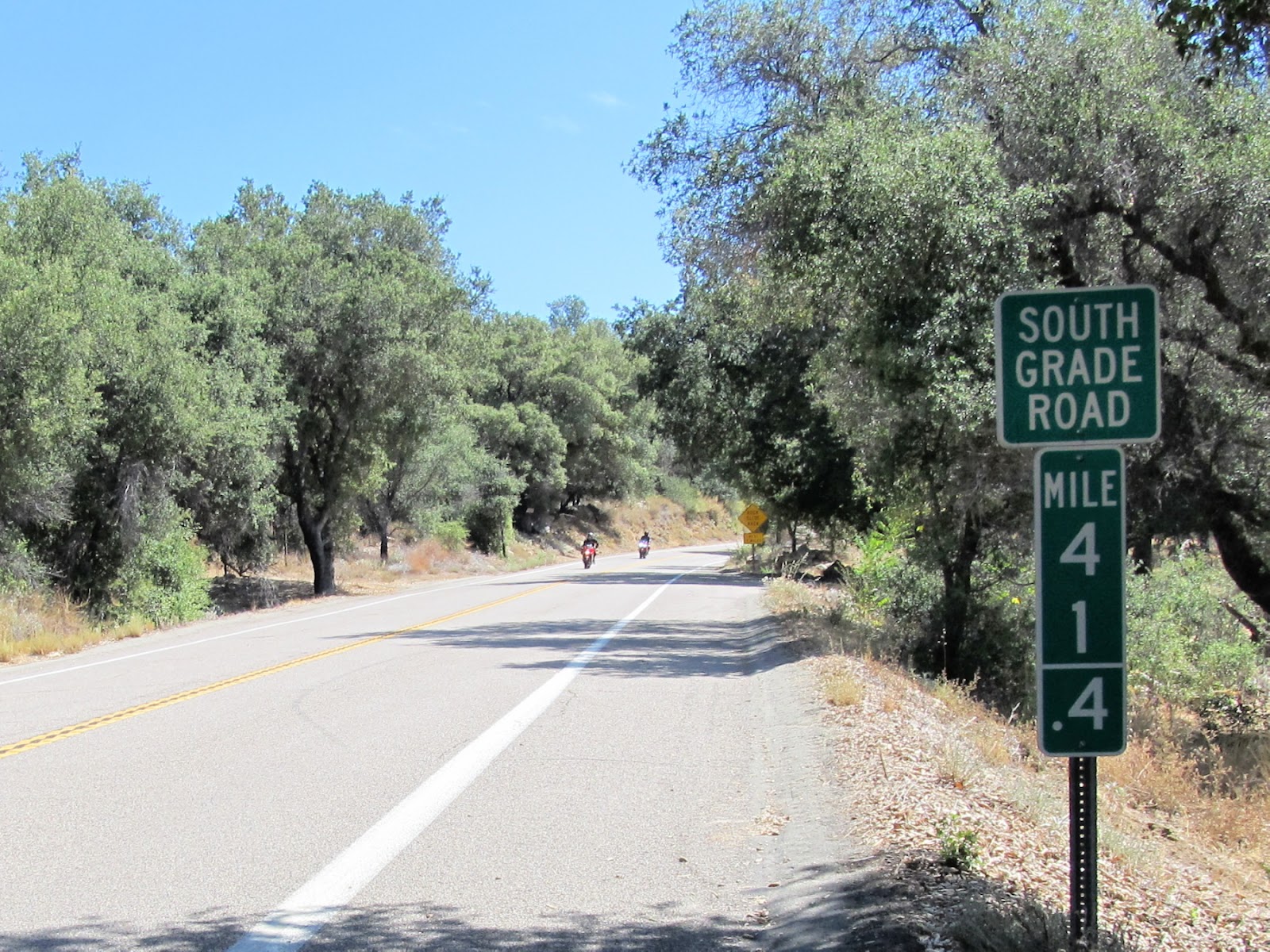
I don’t know why they put down a mileage marker every .2 mile instead of every mile, but it was tremendously helpful in getting me up that twisty road of endless aggravation! I kept promising myself that I’d quit and turn around at the next marker… I got to, say, mile 42.4. It’s at the left-turning switchback, so from the up-lane bike lane I got to take the shallowest incline around and the ride wasn’t feeling so bad. Let’s get to the next marker instead. Got to 42.6, feeling like dropping dead, but there was the 3000 ft elevation marker up ahead. Let’s get to that!
This road sign wasn't talking to me...
Now there... why not get to 42.8? 42.8 was at an icky right-turning switchback where the bike lane goes up the steepest line of the turn… but it would be so unseemly to quit just short of completing another mile! No, go to 43 even and then I can turn back! Got to 43… well the gradient must have dropped half a degree since my legs weren’t feeling so dead. Maybe I’ll make it further yet… Mile 43.2 marker; oh gosh, this is awful. I’m not gonna make it! But how unesthetic! Quitting at .2 beyond a mile? Let’s at least get nearly to 43 ½…. You know the story. I actually don't remember where on the road all the markers are, but that was how it went... Had to keep breaking promises to myself the further I went.

By the 3000 ft elevation sign, though, the most aggravating thing about the climb manifested itself… Dive-bombing kamikaze flies that will crash land on your face in their attempt at eating it! It was past noon now (my original 'turn around time') and I had been sweating up a deluge. The evaporated sweat left salt on my face that the flies found irresistible, so they swarmed around my head like a pack of bees after the Pooh bear. I only managed to get rid of most of them by splashing precious drinking water on my face to wash the salt off every so often.
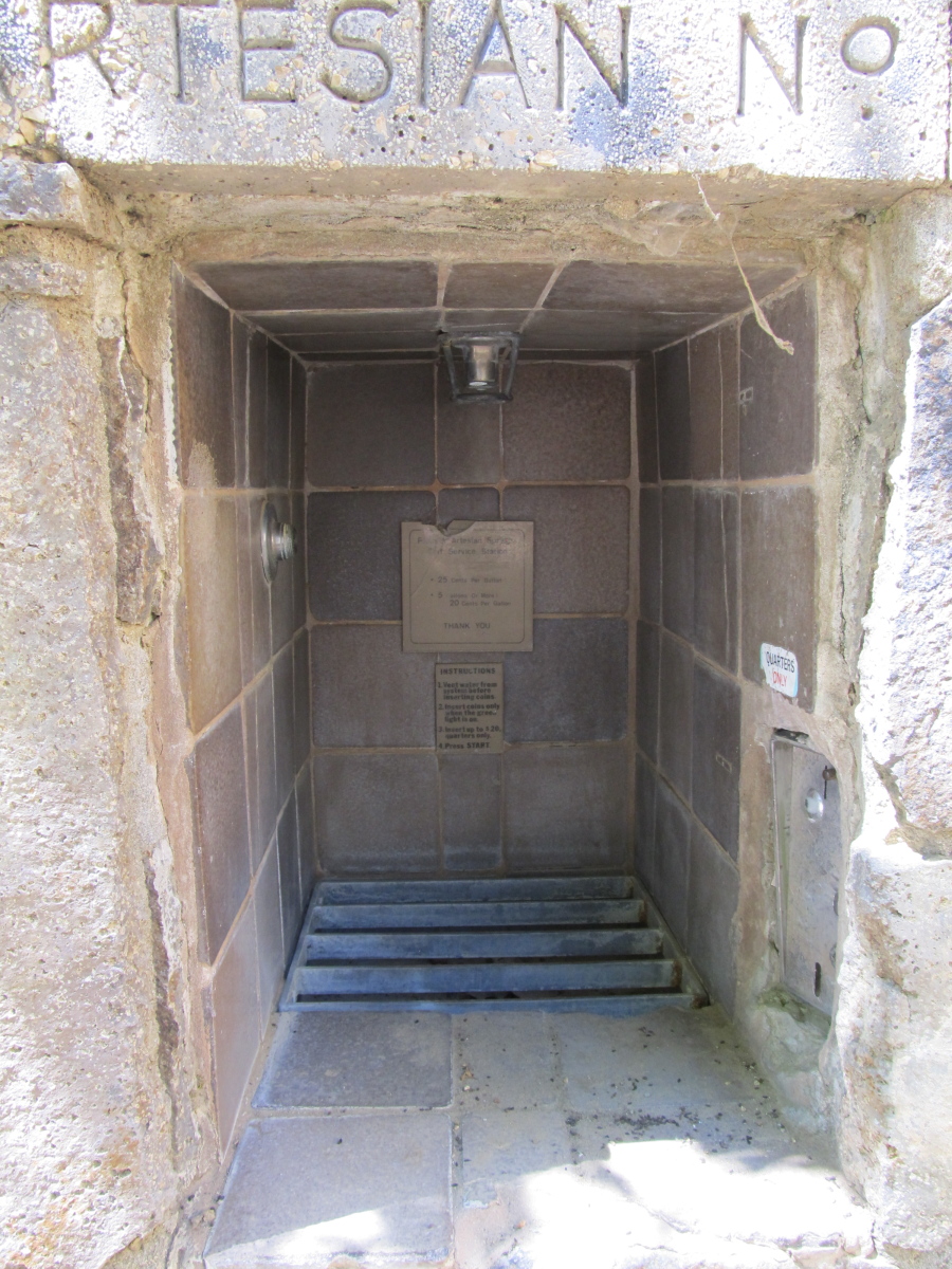
Palomar Artesian Springs on South Grade Rd. All dried up in Sept 2012.
They used to charge 25 cents per gallon, I suppose. None of the faucets are working now. All the levers were removed.
Anyone of you that have heard of the Palomar Artesian Springs a mile or so before the top of the climb can stop counting on it as a source of water refill while climbing this route up the mountain. The levers were removed from all the water faucets. The place still constitute a nice resting spot with its shaded rock wells... I sat there for five minutes or so feeling quite utterly depressed. I didn't know how far I had still to climb and there was now only 2 gulps' worth of water left in my bottles.

(This is getting epic. Part 2 coming up in a bit)